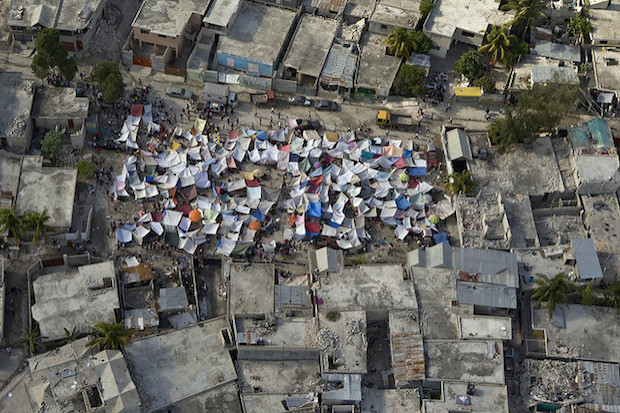
Haitians set up impromtu tent cities thorough the capital after an earthquake measuring 7 plus on the Richter scale rocked Port au Prince Haiti just before 5 pm yesterday, January 12, 2009.
User-generated content can provide a useful source of information during humanitarian crises like armed conflict or natural disasters. With the rise of interactive websites, social media, and online mapping tools, volunteer crisis mappers are now able to compile geographic data as a humanitarian crisis unfolds, allowing individuals across the world to organise as ad hoc groups to participate in data collection. Crisis mappers have created maps of earthquake damage and trapped victims, analysed satellite imagery for signs of armed conflict, and cleaned Twitter data sets to uncover useful information about unfolding extreme weather events like typhoons.
Although these volunteers provide useful technical assistance to humanitarian efforts (e.g. when maps and records don’t exist or are lost), their lack of affiliation with “formal” actors, such as the United Nations, and the very fact that they are volunteers, makes them a dubious data source. Indeed, concerns have been raised about the quality of amateur mapping and data efforts, and the uses to which they are put. Most of these concerns assume that volunteers have no professional training. And herein lies the contradiction: by doing the work for free and at their own will the volunteers make these efforts possible and innovative, but this is also why crisis mapping is doubted and questioned by experts.
By investigating crisis-mapping volunteers and organisations, Elizabeth Resor’s article “The Neo-Humanitarians: Assessing the Credibility of Organised Volunteer Crisis Mappers” published in Policy & Internet presents evidence of a more professional cadre of volunteers and a means to distinguish between different types of volunteer organisations. Given these organisations now play an increasingly integrated role in humanitarian responses, it’s crucial that their differences are understood and that concerns about the volunteers are answered.
We caught up with Elizabeth to discuss her findings:
Ed.: We have seen from Citizen Science (and Wikipedia) that large crowds of non-professional volunteers can produce work of incredible value, if projects are set up right. Are the fears around non-professional crisis mappers valid? For example, is this an environment where everything “must be correct”, rather than “probably mostly correct”?
Elizabeth: Much of the fears around non-professional crisis mappers comes from a lack of understanding about who the volunteers are and why they are volunteering. As these questions are answered and professional humanitarian actors become more familiar with the concept of volunteer humanitarians, I think many of these fears are diminishing.
Due to the fast-paced and resource-constrained environments of humanitarian crises, traditional actors, like the UN, are used to working with “good enough” data, or data that are “probably mostly correct”. And as you point out, volunteers can often produce very high quality data. So when you combine these two facts, it stands to reason that volunteer crisis mappers can contribute necessary data that is most likely as good as (if not better) than the data that humanitarian actors are used to working with. Moreover, in my research I found that most of these volunteers are not amateurs in the full sense because they come from related professional fields (such as GIS).
Ed.: I suppose one way of assuaging fears is to maybe set up an umbrella body of volunteer crisis mapping organisations, and maybe offer training opportunities and certification of output. But then I suppose you just end up as professionals. How blurry are the lines between useful-not useful / professional-amateur in crisis mapping?
Elizabeth: There is an umbrella group for volunteer organisations set up exactly for that reason! It’s called the Digital Humanitarian Network. At the time that I was researching this article, the DHN was very new and so I wasn’t able to ask if actors were more comfortable working with volunteers contacted through the DHN, but that would be an interesting issue to look into.
The two crisis mapping organisations I researched—the Standby Task Force and the GIS Corps—both offer training and some structure to volunteer work. They take very different approaches to the volunteer work—the Standby Task Force work can include very simple micro-tasks (like classifying photographs), whereas the GIS Corps generally provides quite specialised technical assistance (like GIS analysis). However, both of these kinds of tasks can produce useful and needed data in a crisis.
Ed.: Another article in the journal examined the effective take-over of a Russian crisis volunteer website by the Government, i.e. by professionalising (and therefore controlling) the site and volunteer details they had control over who did / didn’t turn up in disaster areas (effectively meaning nonprofessionals were kept out). How do humanitarian organisations view volunteer crisis mappers: as useful organisations to be worked with in parallel, or as something to be controlled?
Elizabeth: I have seen examples of humanitarian and international development agencies trying to lead or create crowdsourcing responses to crises (for example, USAID “Mapping to End Malaria“). I take this as a sign that these agencies understand the value in volunteer contributions—something they wouldn’t have understood without the initial examples created by those volunteers.
Still, humanitarian organisations are large bureaucracies, and even in a crisis they function as bureaucracies, while volunteer organisations take a nimble and flexible approach. This structural difference is part of the value that volunteers can offer humanitarian organisations, so I don’t believe that it would be in the best interest of the humanitarian organisations to completely co-opt or absorb the volunteer organisations.
Ed.: How does liability work? Eg if crisis workers in a conflict zone are put in danger by their locations being revealed by well-meaning volunteers? Or mistakes being being made on the ground because of incorrect data—perhaps injected by hostile actors to create confusion (thinking of our current environment of hybrid warfare).
Elizabeth: Unfortunately, all humanitarian crises are dangerous and involve threats to “on the ground” response teams as well as affected communities. I’m not sure how liability is handled. Incorrect data or revealed locations might not be immediately traced back to the source of the problem (i.e. volunteers) and the first concern would be minimising the harm, not penalising the cause.
Still, this is the greatest challenge to volunteer crisis mapping that I see. Volunteers don’t want to cause more harm than good, and to do this they must understand the context of the crisis in which they are getting involved (even if it is remotely). This is where relationships with organisations “on the ground” are key. Also, while I found that most volunteers had experience related to GIS and/or data analysis, very few had experience in humanitarian work. This seems like an area where training can help volunteers understand the gravity of their work, to ensure that they take it seriously and do their best work.
Ed.: Finally, have you ever participated as a volunteer crisis mapper? And also: how do you the think the phenomenon is evolving, and what do you think researchers ought to be looking at next?
Elizabeth: I haven’t participated in any active crises, although I’ve tried some of the tools and trainings to get a sense of the volunteer activities.
In terms of future research, you mentioned hybridised warfare and it would be interesting to see how this change in the location of a crisis (i.e. in online spaces as well as physical spaces) is changing the nature of volunteer responses. For example, how can many dispersed volunteers help monitor ISIS activity on YouTube and Twitter? Or are those tasks better suited for an algorithm? I would also be curious to see how the rise of isolationist politicians in Europe and the US has influenced volunteer crisis mapping. Has this caused more people to want to reach out and participate in international crises or is it making them more inward-looking? It’s certainly an interesting field to follow!
Read the full article: Resor, E. (2016) The Neo-Humanitarians: Assessing the Credibility of Organized Volunteer Crisis Mappers. Policy & Internet 8 (1) DOI:10.1002/poi3.112.
Elizabeth Resor was talking to blog editor David Sutcliffe.